Deforestation prevention using land use monitoring and valuation (IMAGES) (Vivid Economics) (IPP funded)
Overview
By estimating the value of alternative land uses, predicting forest loss and detecting it in near- real time, IMAGES helps land managers and policymakers understand and prioritise trade-offs in unprecedented spatial, temporal and economic detail.
http://www.vivideconomics.com
Solution benefits
- Analyses land use change scenarios to understand implications of agricultural and forestry policy interventions compared to a business-as-usual case.
- Supports the design of land-use zoning rules and regulations, including high level agricultural, forestry, or climate change targets.
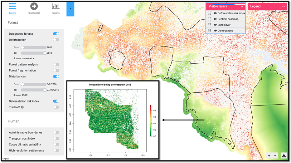
- Helps government enforcement agencies allocate scarce resources to minimise deforestation by identifying times and locations that forests are most at risk of loss or degradation.
- Allows policymakers to quantify, value and visualize the valuable ecosystem services forests produce to better inform investment planning.
- Enables the issuance of zero-deforestation conditional land titles through very high-resolution plot-level mapping.
- An easy-to use web-based platform enables interactive user analysis for non-experts, and access to all of the project’s data layers for expert users.
Key technical features
- Combines static land use classification rasters constructed using Sentinel-2 optical EO data with Sentinel-1 radar EO data based forest disturbance information to generate a historic time-series of land use since 2016 at a 10 metre spatial and 2 week temporal resolution.
- Creates predictive modelling based on econometric and machine learning techniques to understand likely paths for land use change over a 10+ year time horizon.
- Uses natural capital valuation techniques to quantify and value a series of ecosystem services including water provision, water filtration, sediment retention, ecotourism and carbon sequestration.
- Can be flexibly adapted for use with any land use classification raster, making it applicable to a wide variety of locations and resolutions.
- Available as a standalone web interface but can be integrated into solutions hosted by other platforms as economic modelling layers able to utilise a wide variety of land use rasters.
Case studies
Ivory Coast: Vivid Economics, supported by IPP, is working closely with the UN REDD+ Secretariat and the Ministry of Water and Forests, as well as other parties in Ivory Coast to use IMAGES to inform policy choices in the country.
Peru: Vivid Economics, supported by IPP, is using IMAGES to support the national and regional government’s planning and implementation of land- use zoning, productive investments, and ‘conditional land titling’ in the San Martin region of Peru.
Organisation overview
Vivid Economics is a leading economics strategy consultancy with global reach. Specialising in cities, climate change, economic development, energy, finance and natural resources, we advise on the most critical and complex policy and commercial questions facing clients, both in government and the private sector, around the world.
Central to our work is robust, evidence-based analysis communicated effectively. We have wide- ranging expertise and skills in commercial strategy, public policy design, economy-wide and market modelling, econometrics and spatial analysis. Our experience is demonstrated in a track record in delivering first-of-a-kind, custom solutions with solid economic foundations.
