Using Earth Observation for Disaster Resilience Planning and Policymaking
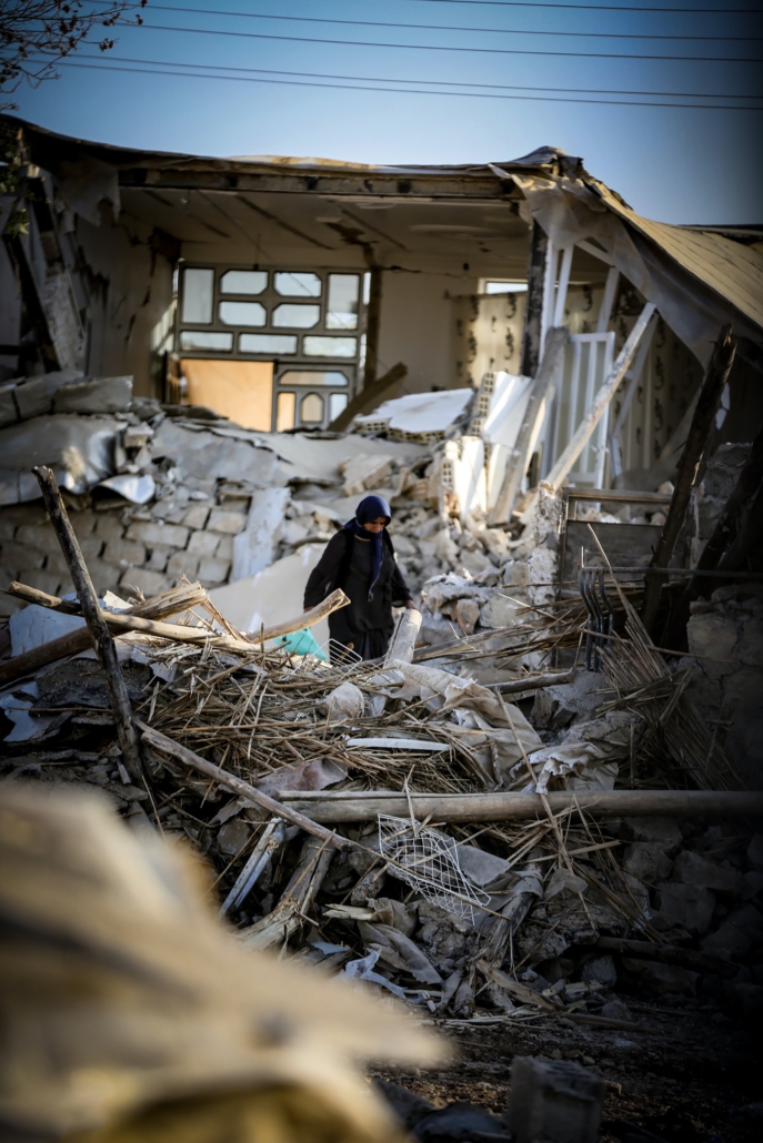
Each year natural disasters negatively impact hundreds of thousands of lives and lead to economic losses averaging US$250-300 billion per annum. These losses are often disproportionately high in developing countries that experience high-rates of poverty and rapid urbanisation, which pushes the most vulnerable into increasingly hazard-prone areas. Furthermore, the Least Developed Countries (LDCs) are challenged by a lack of resources to effectively understand risk, implement mitigation measures, and respond to disasters.
The METEOR project, funded through the International Partnerships Programme (IPP), is using satellite imagery to provide disaster management agencies with an improved understanding of exposure, hazard and vulnerability in specific geographies so that they can better estimate future losses from natural hazards and therefore understand the potential benefits of mitigation. Gaining access to the outputs of the METEOR project could lead to any number of subsequent actions to be taken, including land-use decisions, and building code adoption or enforcement decisions that reduce the annual probability of direct building damage, indirect social disruption, and loss of life. In addition, early post-event estimates can be used to prioritize search and rescue and the distribution of resources.
The METEOR project started in February 2018 and is planned to last for 3 years. In July, the METEOR project consortium came together in Edinburgh for the first of their annual learning events. The consortium is led by the British Geological Survey (BGS) and includes the Global Earthquake Model (GEM) foundation, Image Cat, the Humanitarian OpenStreetMap Team (HOT), flooding experts Fathom and M&E partners Oxford Policy Management (OPM). The meeting also included representatives from the international project partners for the two focus countries – the Nepal National Society for Earthquake Technology (NSET) and the Tanzanian Disaster Management Department of the Prime Minister’s Office (DMD, who joined remotely). Members of the project’s Advisory Board also took time away from their regular day jobs at World Bank, UNISDR and DFID to hear more about the progress made on the project and to share their feedback and recommendations on next steps.
The project focuses on geological hazards of specific significance within the two focus countries of Nepal (earthquakes, flooding and landslides) and Tanzania (earthquakes, flooding and volcanoes). A dedicated web portal which is currently under construction will host a number of datasets and maps produced by the METEOR consortium partners as well as protocols that will enable government agencies to keep information up to date and relevant beyond the IPP grant period. The aim is for METEOR outputs to be disseminated through a number of existing platforms and portals that government agencies already use rather than to duplicate the number of available data sources. A working group has also been established with members of the insurance sector to understand how METEOR outputs could also have commercial use cases and be integrated into existing business workflows to price new insurance products.
Over the coming months, the team will continue to engage in-country partners and will broaden their network to include relevant governmental agencies in the run-up to the delivery of training on the use of the outputs next year. This will include producing a number of communications materials customised to a variety of user needs to better explain how METEOR outputs can be taken up by in-country stakeholders. Over the longer term, the more partners can access and use the datasets for planning and practice, the more likely there will be changes in behaviour and policy that can mitigate the effects of natural hazards.
The IPP programme has a number of projects working to support improved disaster resilience, response and management (more details can be found here www.spacefordevelopment.org). Caribou Space, the UKSA’s M&E partner, have written a report on how space technology has a critical role to play in this sector – the report can be found here.
Key Definitions[1]
Hazard: A process, phenomenon or human activity that may cause loss of life, injury or other health impacts, property damage, social and economic disruption or environmental degradation.
Exposure: The situation of people, infrastructure, housing, production capacities and other tangible human assets located in hazard-prone areas. These can be combined with the specific vulnerability and capacity of the exposed elements to any particular hazard to estimate the quantitative risks associated with that hazard in the area of interest. In terms of the METEOR project, exposure focuses on buildings.
Vulnerability: The conditions determined by physical, social, economic and environmental factors or processes which increase the susceptibility of an individual, a community, assets or systems to the impacts of hazards.
[1] Oxford Policy Management definitions (2019)