
Peatland Monitoring (CGI) (IPP funded as PASSES project)
http://www.cgi-group.co.uk
Overview
Peatland Assessment in SE Asia by Satellite (PASSES) provides wide area observations of peat surface motion via the innovative PeatMotion product that can inform enhanced peatland restoration planning and assessment to assist with sustainable use of peatlands.
Solution benefits
- PeatMotion offers cost effective and routine monitoring of surface motion over very wide and often inaccessible areas of tropical peatland. This regional-scale insight can enable better planning and prioritisation of inspections and restoration activities.
- Surface motion information can also provide proxy observations for key characteristics such as changes in water table depth and greenhouse gas emissions.
- The PeatMotion product is derived from Sentinel-1 radar imagery which is unaffected by cloud, and is available free and open from the EU Copernicus programme, ensuring reliable observations and consistent monitoring.
Key technical features
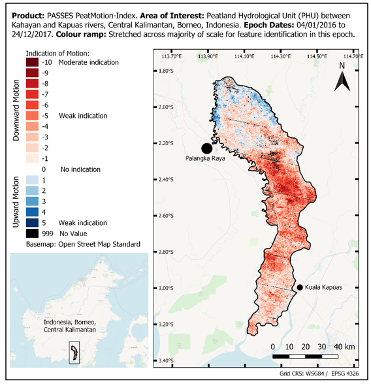
- The PeatMotion product delivers an indication of surface motion, informing the user of the direction of motion (downwards or upwards), the strength of motion detected, and the time period over which the motion applies.
- The direction of motion can be related to normal ground movements of subsidence (downwards motion) and uplift (upwards motion).
- The strength of motion represents the likelihood and potential magnitude of actual motion in the landscape. If a strong motion signal is detected, it indicates that actual ground motion in that location is highly likely. If a weak motion signal is detected the landscape is likely to be stable.
- The PeatMotion product is derived from approximately two-years of Sentinel-1 observations over each site, hence each product is an average indication of motion encompassing that two-year period.
- Alongside the core surface motion information are supporting statistics layers to assist the user with understanding how the indication of motion compares to the underlying variation of the input raw data.
- The product is a geospatial raster, in Geotiff format, with pixel size of 250 m. Landscape-scale features, such as a peatland hydrological unit or region of forest / agriculture, can be investigated using one or more pixels of this size.
- The PASSES products cover the peatlands of Indonesia and Malaysia, with the earliest observations starting in 2016.
- PASSES products are available for discovery and download via a web portal. Once downloaded, users can analyse and retain the complete PeatMotion datasets in their own systems.
Case studies
PeatMotion datasets have been produced and are available for users to trial. An example case study for the data is a user who wants to assess the impact of restoration activities in an area of peatland. In this area a number of artificial drainage channels have been blocked in an attempt to return the water table to its original pre-drainage levels to encourage re-wetting and revegetation with native species. The user has placed a small number of in-situ surface height sensors across the peatland to monitor the expected uplift caused by raising the water table, however the region is remote and the user would like a more complete view of the surface motion over the years of restoration.
The PeatMotion products are produced for the years before and during the restoration, and they show an initial indication of weak downward motion changing around the time of the drainage blocking to consistent moderate upwards motion indicative of the peatland re-wetting and uplifting. The user fuses their “point source” in-situ measurements with the wide area PeatMotion product to report the outcomes of restoration activities over the complete area.
Organisation overview
CGI is the 5th largest IT services company in the world operating across a broad range of industries, including over 40 years’ heritage in the space industry. CGI builds and delivers complex, mission-critical space systems. Our solutions are secure, often in complex technical environments, proven to work first time, every time, ultra-reliable and delivered on time to avoid costly delays.
CGI is the prime contractor for the PASSES project, with the following project partners: Centre for Ecology and Hydrology, IPE Triple Line, Liverpool John Moores University, Nottingham University, Terra Motion, University of Leicester.