C-RISe Near Real Time Marine Information Service (Satellite Oceanographic Consultants Limited) (IPP funded)
www.c-rise.info
Overview
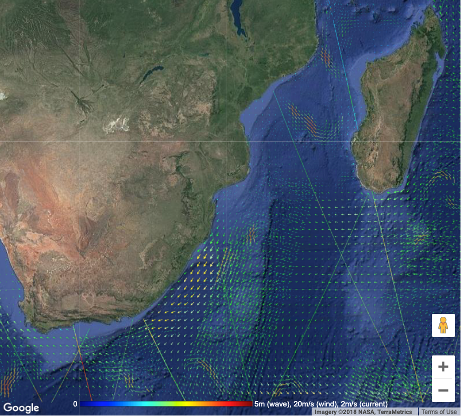
C-RISe Near Real Time Marine Information Service – provides hourly updated satellite derived information on marine weather conditions, to provide the latest information on waves and winds, supporting planning of marine operations and warning of severe conditions as they approach. Satellite Earth observation (EO) data provide a valuable source of information on marine conditions, especially for fast moving intense weather systems during the tropical cyclone season.
Solution benefits
- In situ data on marine conditions are sparse in the South-West Indian Ocean, and there is limited availability of local marine forecasts.
- Satellite EO provides a valuable source of information on marine conditions, especially for fast moving intense weather systems during the tropical cyclone season (November – May).
- C-RISe provides the latest satellite measurements of ocean winds and waves, overlaid on a model forecast, in an easy to use web format.
- These data can then be used in a range of applications including: maritime safety through search and rescue support and operational planning for illegal logging, smuggling, pollution.
- Improved tropical storm information.
Key technical features
- Sources of satellite ocean wind and wave data are polled every 10 minutes to identify new measurements in the South-West Indian Ocean region.
- New data are identified, processed and loaded onto data tables, and presented on an interactive web interface that can be panned, zoomed and queried.
- These data are presented along-side the latest US NOOA WaveWatch3 model forecast for the region.
- The source data can be accessed directly for integration onto local presentation systems.
- The data provided are open access, provided that the source is acknowledged in any application.
- The satellite data are:
− satellite altimetre (Jason-2, Jason-3): significant wave height, wind speed, along track, seven kilometre interval. Irregular sampling due to satellite orbit, typically 10-15 passes per day in the region
− satellite scatterometre (Metop /ASCAT): wind speed and direction 550 kilometre wide swath, 25 kilometre grid resolution, twice daily passes
− surface current speed and direction from the ESA Globwave project, on a global 11 kilometre grid, updated daily
• The model forecast data:
− include US NOAA Wavewatch3 model,
wind speed and direction, wave height, period and direction. Global 0.5° model (55 kilometre grid at the equator), updated every six hours
− can be viewed on any computer or smart phone with an internet connection and web-browser. No further local computing capacity is necessary
Case studies
C-RISe is being implemented, with Mozambique, Madagascar and South Africa to provide satellite-based information on sea level rise, storm surges, extreme wind speeds and wave heights, supported by IPP. The goal is to enable local stakeholders to use this information to reduce the social and economic impact of coastal hazards and increasingly variable weather patterns. This is with international partners: Mozambique National
Meteorological Office (INAM); the Mozambique National Maritime and Coastguard Agency (INAMAR); the Madagascar Meteorological Office (DGM); and the Madagascar National Centre for Maritime Information (CFIM).
Organisation overview
Satellite Oceanographic Consultants Limited (SatOC) is an SME, founded in 2008, with the aim to develop and promote practical applications of satellite oceanography, working with industry, the research community and commercial and institutional end users. Our principal technical expertise is on satellite measurements of ocean winds, waves and currents. We also have close association with specialists on satellite optical, infrared and synthetic aperture radar (SAR) imagery from which information on sea surface temperature, water quality parameters and other oceanographic features can be obtained. This gives us a full understanding of all techniques and applications of satellite oceanography.
