Service4EO (Deimos Space UK)
www.elecnor-deimos.com/delegacion/deimos-space-uk
Overview
Service4EO is a back-end platform that delivers Earth observation (EO) products to applications that address a range of problems in developing countries. It collects and ingests EO data from satellites and drones combined with data from ground sources and processes the data to applications for sectors such as agriculture, urban mapping, forestry and coastal management. Service4EO targets organisations which want to develop applications using EO data from different sources without having to manage the complexity of integrating and processing the EO data.
Solution benefits
- Service4EO targets organisations which want to develop applications using EO data from different sources without having to manage the complexity of integrating and processing the EO data.
- It offers an easy integration and access to EO data from free and commercial satellites, for non-experts.
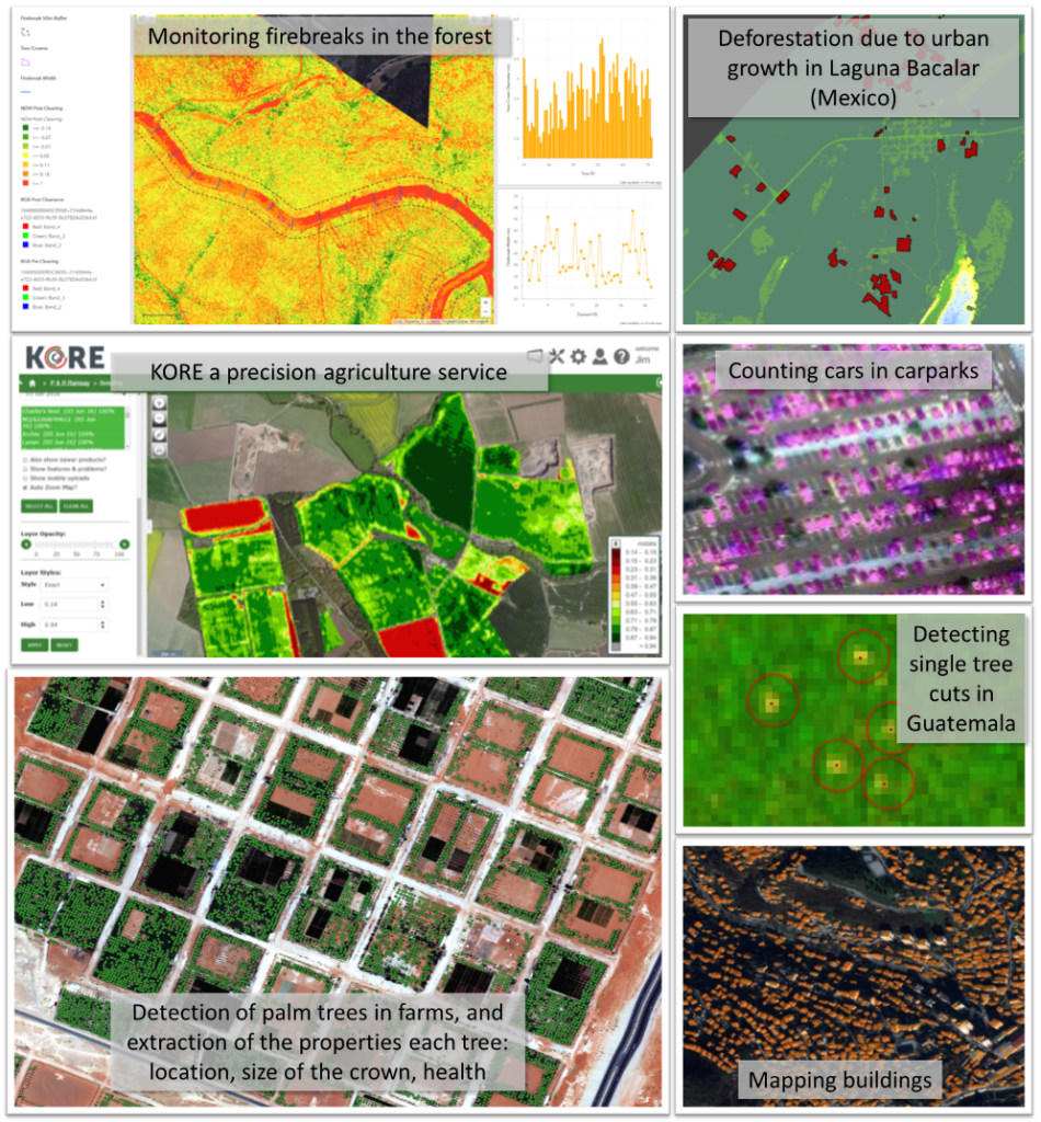
- It is ideal for applications which need to monitor multiple small geographic Areas of Interest (AOI) with different sensors for different environmental conditions, with near real time delivery.
- Service4EO has a cost-effective design to provide data with at minimum cost.
- Service4EO is based on the latest Artificial Intelligence techniques.
- Service4EO has a cost-effective design to provide data with at minimum cost.
- Service4EO is based on the latest Artificial Intelligence techniques.
Key technical features
- It ingests and integrates both satellite and unmanned aerial vehicle (UAV)/drone imagery provided by end users.
- Service4EO uses machine learning and advanced neural network algorithms (forms of artificial intelligence) to extract insights from imagery.
- A subscription application programming interface (API) is available to define the areas of interest, the acquisition plans and the services to subscribe. Service4EO will automatically deliver the required products to the application based on subscriptions.
- Currently supports a range of EO sources including Sentinel 1-2, Landsat 8, RapidEye, Deimos 1-2, Worldview 1-3, PlanetScope, Superview, Gaofen1-3 and others, down to a resolution of 30 centimetre.
- This range of EO sources provide a temporal resolution of several images per day to one image per year (depending on the acquisition plan for the targeted application).
- Processing of UAV imagery to generate mosaics and digital elevation models and other products down to a resolution of 1 centimetre.
- Service4EO has a library of services/products from vegetation index (chlorophyll content index and soil reflectance adjusted index) to advanced object detection (car counting, building extraction, plants detection and forest fire scars).
- Service4EO can be hosted in a scalable cloud (e.g. Amazon Web Service) or a local secured infrastructure. It can be operated by Deimos or any third-party.
Case studies
Part of the eOsphere SIBELIUS project in Mongolia, supported by IPP, to help the herders to get a better insurance policy for livestock losses due to severe weather conditions and to find grass or shelters during drought or heavy snow.
Organisation overview
Deimos Space UK was created in 2013 as a branch of Elecnor Deimos to address the UK and UK-export market for space systems, services and applications. The company offers expertise in flight systems, ground segment systems, space situational awareness, satellite navigation, applications and services. The knowledge of satellites, data systems and location-based services puts the company in a unique position when developing satellite applications.
