Satellite-Structural Health Monitoring (S-SHM) & Satellite Ultra-Precise Motion Monitoring Integrated Technology (SUMMIT) (Telespazio VEGA UK)
http://telespazio-vega.com/
Overview
Satellite-Structural Health Monitoring (S-SHMTM): Innovative use of satellite technologies in ground motion based structural engineering monitoring. It is a highly scalable solution that can monitor a single piece of infrastructure up to city-scale survey – to detect structural and ground motions.
Satellite Ultra-Precise Motion Monitoring Integrated Technology (SUMMIT): Monitoring of ground motion of specific infrastructure using Global Navigation Satellite Systems (GNSS).
Solution benefits
Satellite-Structural Health Monitoring (S-SHMTM):
- Allows infrastructure asset managers to assess specific structures such as bridges, dams, flyovers, buildings for ground movement impact on the structure.
- Provides a three-dimensional view of infrastructure asset health by monitoring ground movements.
- Allows long term preventive maintenance of the infrastructure asset.
- Works in most weather conditions including cloud.
- Precise structural and ground motion detected in order of 2-3 millimetres.
- No in-situ equipment or site access required over large areas.
- Multiple infrastructure assets can be monitored simultaneously.
Satellite Ultra-Precise Motion Monitoring Integrated Technology (SUMMIT):
- Remote monitoring of strategically targeted infrastructure assets in real time.
Key technical features
Satellite-Structural Health Monitoring (S-SHMTM):
- Uses radar that works in cloudy conditions.
- Combines Interferometric SAR (InSAR) derived point cloud data and three-dimensional models of the infrastructure.
- Uses high resolution commercial COSMO- SkyMed SAR data, in either Spotlight (one metre) or StripMap (three metre) modes to match customers’ needs.
- An innovative InSAR method using Persistent Scatterer Interferomerty (PSI) is applied.
- Utilises solid points on buildings, rock and poles to build a picture of up to 300,000 points per image to monitor ground movement.
- InSAR combined with three-dimensional Building Information Modelling (BIM) to map structure and ground motion.
- Colour indexed point data for each PSI visualises the amount of movement that has been observed.
- A standalone solution implemented on Telespazio’s computing infrastructure; a user with an asset management portal can access the output of the S-SHM tool via JSON format.
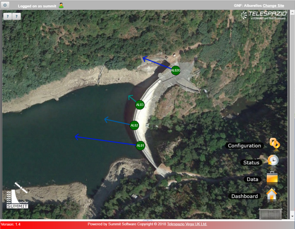
Satellite Ultra-Precise Motion Monitoring Integrated Technology (SUMMIT):
- In house developed software and GNSS hardware to provide real time GNSS measurements of ground movement.
- Data generated every minute and updated to the server every five minutes.
Case studies
S-SHMTM: Satellite Structural Health Monitoring
– was developed under InnovateUK funding to provide structural specific assessment based upon the use of Persistent Scatterer InSAR (PSI) data. This supported an assessment of Transport for London’s (TfL) East India and Canning Town stations and showed displacement movements.
SUMMIT applied to Tailing Dams monitoring – SUMMIT is being used in the IPP supported project ‘Space-based dam monitoring’ in Peru with HR Wallingford. Two targeted tailing dams will be monitored with both the SUMMIT system and the InSAR S-SHMTM; one dam site is abandoned with potential risk of leakage and the other is an active tailing dam.
Organisation overview
Telespazio VEGA UK Ltd (TVUK) is a highly experienced consulting, technology and engineering services business, which supports satellite operators and manufacturers worldwide and helps other organisations benefit from space data and services. Based in the UK, it is a wholly owned subsidiary of Telespazio SpA, and employs approximately 140 highly qualified staff with a wide experience in Science, Earth Observation, Geo- Information, Navigation and Telecoms Projects.