Exposure and Multi-hazard Data for Disaster Risk Management (METEOR) (British Geological Survey) (IPP funded)
Overview
The overall aim of METEOR [Modelling Exposure Through Earth Observation Routines] is to provide robust national-scale exposure and multi-hazard information based on Earth observation (EO) data. Consistent, reliable information on exposure (building location and construction type) along with multi-hazard knowledge (i.e. how hazards such as earthquakes and landslides occur and interact) is vital when building resilience to hazards and contributing to sustainable development in countries on the OECD list.
Solution benefits
- National-scale robust exposure data providing consistent and validated information on building type and construction for disaster risk management.
- National-scale hazard and multi-hazard data covering earthquakes, floods, landslides and volcanic events.
- Protocols outlining how the outputs are derived is freely available to ensure confidence in the results and replicability/updates in the future.
- Outputs are freely distributed for use by a wide range of stakeholders across policy, technical and NGO sectors.
- Co-designed and co-developed with stakeholders to ensure outputs are fit-for-purpose, understood and used.
- Strengthened national and regional awareness and technical capacity when planning for and responding to disasters such as earthquakes, floods, landslides and volcanic eruptions.
Key technical features
- The solution is based on day- and night-time optical satellite imagery; synthetic aperture radar (SAR) data and digital terrain models validated by ground data.
- EO data provides a reliable and cost-effective way to deliver outputs in potentially data-poor areas and those that are difficult to access.
- Outputs are formatted to integrate into existing and prototype national Disaster Information Management Systems.
Case studies
METEOR is currently being developed with international partners, supported by IPP.
Nepal is represented by the National Society for Earthquake Technology (NSET). Nepal is a multi- hazard prone country. NSET maintains a database of 29 types of disaster that have affected Nepal since 1971. In 2015 the Gorkha earthquake and associated landslides caused over 9000 fatalities, injured nearly 22,000 people and destroyed over 470,000 buildings. In Nepal, METEOR is focussing on national exposure data with earthquake, landslide and flood multi-hazard analyses.
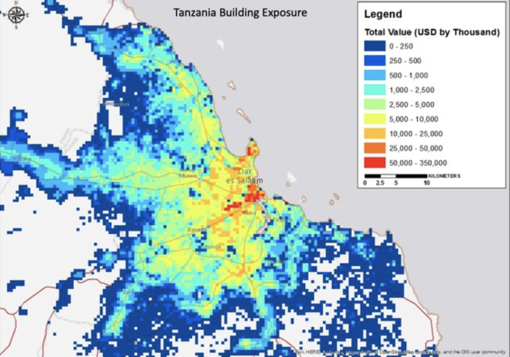
Tanzania is represented by the Department for Disaster Management, Prime Minister’s Office. The average annual loss from multi-hazard events in Tanzania is estimated at nearly US$64M1. The hazard contribution is 60% from flooding and 40% from earthquakes while there is an estimated 2.5 million people living within 30km of a volcano. In Tanzania METEOR is focussing on delivering national exposure data with earthquake, flood and volcanic multi-hazard analyses.
METEOR will also deliver national exposure data for the remaining 47 Least Developed Countries (LDC’s) on the DAC list of ODA recipients.
Organisation overview
METEOR is led by the British Geological Survey (BGS) (http://www.bgs.ac.uk). BGS is a component organisation of UK Research and Innovation (UKRI) which is the UK’s leading body for basic, strategic and applied research. BGS was founded in 1835 and is the world’s longest established national geological survey. The ‘Geodesy and Earth Observation’ area has a mixed funding portfolio including projects funded via ESA/EU, NERC (UK), World Bank, Innovate UK (UK) and DFID (UK).
BGS addresses a number of different challenges including ‘Decarbonisation and Resource Management’, ‘Environmental Change Adaptation’ and ‘Multi-hazards and Resilience’.
METEOR consists of several components led by expert organisations in their fields:
• Exposure development – ImageCAT Inc
• Landslide and volcanic hazard – British Geological Survey
• Seismic hazard – Global Earthquake Model Foundation
• Flood hazard – Fathom Ltd
• Multi-hazard modelling – British Geological Survey
• Field data collection – Humanitarian OpenStreetMap Team
• Monitoring and Evaluation – Oxford Policy Management