Crop Observation, Management & Production Analysis Services System (COMPASS) (Rezatec) (IPP funded)
www.rezatec.com/resources/projects/mexican-compass/
Overview
The Crop Observation, Management and Production Analysis Services System (COMPASS) uses satellite Earth observation (EO) data to help smallholder farmers manage their sugar cane and wheat agriculture. It helps optimise crop productivity by identifying factors that cause the yield gap between crop potential and actual field performance. It also provides agronomic support to advisory services, agribusiness, farmer co-operatives, crop insurers and governments.
Solution benefits
- Improved productivity for wheat and sugar cane smallholder farmers.
- Improved resource use efficiency and hence lower emissions of fertiliser nitrogen and greenhouse gases (GHGs) to the environment.
- Improved market function as farmers, traders, government and other stakeholders will have improved information on likely crop yields, allowing much better planning of crop marketing, which helps to stabilise incomes.
- Regular updates with greater accuracy of crops status than can be achieved on the ground for thousands of farms.
- Crop progress effectively benchmarked against comparator farms and local and regional averages to give farmers the information they need to improve performance.
- Crop growth map covering all the crops in the area supports industries to plan marketing of crops and for insurance companies and government to plan insurance cover.
- Assist farmers in crop management activities, including optimum sowing period and optimum irrigation schedule.
- Irrigation bodies, processors and crop insurance companies gather agricultural data through COMPASS, saving costs spent on third party surveyors to gather this information manually.
- Assist crop insurance companies to monitor each customer’s (farmer) crop management activities and through satellite’s crop health status
- thereby help assessing appropriate discount rates to individual farmers based on their crop management performance.
- Assist crop insurance companies with updates on yield prediction on associated farms and review historical data during claims.
- Assist wheat processors with expected yield from the associated farmers within the supply chain for plant production/process optimisation.
- Assist irrigation bodies to evaluate and map supply demand to the associated farm lands and optimise operation with accurate information provided by the farmers through the Compass mobile app.
Key technical features
- Uses Sentinel-2 EO data, in combination with commercial EO data.
- Uses Sentinel-2 multi-spectral data, with 12 spectral bands, at 10 metre resolution. This data has a five-day revisit period, which makes it ideal for monitoring crop yield.
- EO data is combined with 30 site-specific parameters grouped by soil, management, inputs and environment that determine the production efficiency of wheat and sugar cane crops, e.g. soil type, harvest date, disease control and temperature.
- Assist the wheat and sugarcane farmers to monitor their crop health every week with satellite and crop model data analysis.
- Advises farmers of the potential gap in their crops forecast yield versus maximum potential yield, optimal sowing and irrigation dates.
- Provides a log of crop management activities and reminders from sowing until harvest.
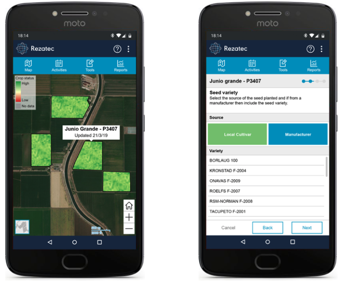
- Farmers just require a mobile phone or desktop plus an internet connection. No other IT infrastructure is required.
Case studies
Rezatec is providing COMPASS in Mexico to help smallholder farmers growing sugar cane and wheat to improve crop management, in partnership with CIMMYT and COLPOS. Mexican farmers need to improve crop productivity and stabilise their incomes to facilitate rural community economic development.
Organisation overview
Rezatec helps businesses improve the management of their land-based assets by providing intelligent insight based on analysing a complex array of geospatial information, including advanced EO data. High-value landscape insights are provided to clients via our web portal giving exclusive access to pre-packaged and custom-built landscape intelligence products. Through custom dashboards, users can upload, download, add or edit data modelling and manipulate the visualized map with show/hide data layers.

