Blog by UNOSAT. CommonSensing: From Covid-19 Recovery to Climate Resilience (IPP Project Blog)
This article was provided by UNOSAT.
IPP CommonSensing aims to support the three selected Commonwealth Small Island Developing States (SIDS) by improving national climate resilience through the use of satellite remote sensing applications. To address climate challenges faced by the partner countries, the consortium has pioneered an innovative project delivery structure, in which a geospatial information portal (the IPP CommonSensing platform) with four web applications – a climate information app, risk information app, map explorer app, and a decision support system – and data cube of 14 products were developed to provide stakeholders with reliable data. These means have been supported by enhanced knowledge and skills on geospatial applications through capacity development trainings. During the two-year implementation period of 2019-2020, consortium partners delivered eight face-to-face technical trainings, two online trainings, 36 outreach awareness-raising events, and 43 technical awareness-raising workshops, reaching 1039 beneficiaries with a gender ratio of 60 percent male and 40 percent female.
While the CommonSensing Platform is partially operational, one portion of the project’s activities has filled that technical gap through the provision of ad-hoc geospatial data, information and tools that allow for on-the-job application of knowledge and skills gained from capacity development trainings.
These technical backstopping activities have been a much-lauded service that stakeholders have considered key in their daily activities. The success of the service has contributed to the overarching goal of the project to provide technical solutions and the capacity to use the tools, as stakeholders have used the provided data, tools and information to support decision-making processes on numerous programmes and policies, including during emergencies and throughout the time-sensitive disaster management cycle.
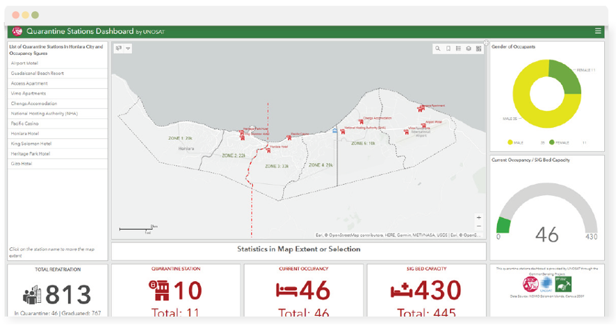
Solomon Islands: Covid-19 Dashboard
Most nations in the Pacific have been spared the worst of the health crises caused the Covid-19 pandemic, owed to preemptive lockdowns which have helped to keep infection levels low and prevented medical facilities from being overwhelmed. To ensure those figures remained low, the National Disaster Management Office (NDMO) of the Solomon Islands reached out to UNOSAT’s technical backstopping team for a covid-19 dashboard to centralise information. Jonathan Tafiariki, the NDMO Deputy Director, has known the IPP CommonSensing project very well since its inception, due to the project’s continued cooperation with the Ministry through trainings and backstopping. At the time of the interview in August 2020, the Solomon Islands had not recorded a single locally transmitted case but remained wary in a state of emergency allowing for measures such as quarantine stations to be instituted.
Mr. Tafiariki exclaimed that the government needed assistance in preparing for such arrangements and that main challenge was having readily available information available to different ministries and departments, emphasizing that information sharing was key. He stated that they would benefit from a central of point of access, so his team had begun discussion with UNOSAT for what they required on a dashboard. Mr. Tafiariki stated, “we heard UNOSAT helped Vanuatu by creating a dashboard for TC Harold, so we thought it would be great to ask for similar support”.

Sites for returning citizens on repatriation flights had already been established, the government just needed a consolidated dashboard to display which quarantine stations were empty, reaching capacity, or full. Mr. Tafiariki added that the dashboard had helped the different government agencies involved in Covid-19 response efforts obtain centralized information, allowing for quick decision-making and planning for operations. This data was especially key for local police and health workers who would have to react quickly to ill returnees. He also added that the provision of the dashboard assisted operation centers, so the government could see the full picture, so they could plan how to disperse services. The deputy director closed his remarks by stating, “we expected the dashboard to provide us with a clear picture of the situation to allow us to contain the situation” adding that it had helped “create some peace of mind for operations manager who are currently struggling to stay abreast with this information”.
You can read full stories of the IPP CommonSensing case study, such as the Emergency Response Dashboard of Tropical Cyclone Harold for Vanuatu and the Mangrove Map for Fiji, here.
Related links:


