Humanitarian Rapid Mapping Service (UNOSAT)
www.unitar.org/unosat
Overview
UNOSAT provides rapid satellite imagery analysis during natural and environmental disasters to improve situational awareness and support relief efforts. Our staff is able to process requests on a 24/7 basis year-round. Output products include maps, GIS- ready data, statistics and reports. They are shared with governments, UN agencies and other actors.
Solution benefits
- Enhanced situational awareness – know how various areas are affected by the disaster as well as who and what is at risk to ensure an efficient disaster response.
- Wide range of products – assess and map the impact of many types of disaster including floods, fires, chemical waste, oil spills, earthquakes, storms, landslides and volcano eruptions.
- All disaster stages – rapid risk assessments to rapid damage estimation, humanitarian access and reconstruction monitoring.
- Rapidity – a plan scheduling imagery collection and analysis is sent within a few hours, and our first maps are usually shared within three days, 24/7 year-round.
- Continuous follow-up – sharing of additional products as the situation evolves and as new information from the field allows for data refinement.
- Access hard-to-reach areas – satellite imagery provides information about areas that would normally be too dangerous or too costly to access.
- Clear and objective information – as part of the United Nations, UNOSAT strives to provide unbiased and unambiguous information.
- Coordinated approach – to prevent redundancy, mapping efforts are coordinated with other organisations providing satellite analysis through the Global Disaster Alert and Coordination System (GDACS) Satellite Mapping Coordination System (SMCS).
Key technical features
- Free – this service is free of charge for UN Agencies, UN Member States and NGOs.
- Multiple data sources – uses optical and radar imagery ranging from very high resolution (∼30 centimetre) data from commercial providers, to medium resolution (∼30 metre) data from Landsat, depending on needs.
- Privileged access to imagery – able to obtain imagery using the International Charter: Space and Major Disasters, as well as commercial imagery using in-kind contributions.
- High update frequency – uses the most recent data available and updates the products accordingly, providing at best same-day imagery.
- Multiple levels of detail – products can cover territories at the regional scale, national scale and local scale to answer needs.
- Flexible formats – depending on the nature of the disaster and the capacities of the targeted audience, we can provide simple maps and reports accessible from a web browser, raw GIS data and online live maps reflecting the evolution of the situation.
- Strong link with the field – the UN-Adaptative System for Image Communication over Global Networks app (UN-ASIGN) to allow users to directly upload field photos on our live maps.
- Cutting-edge infrastructures – UNOSAT is hosted at the European Organisation for Nuclear Research (CERN) in Geneva and benefits from its outstanding IT infrastructures to store imagery and host online live maps.
Case studies
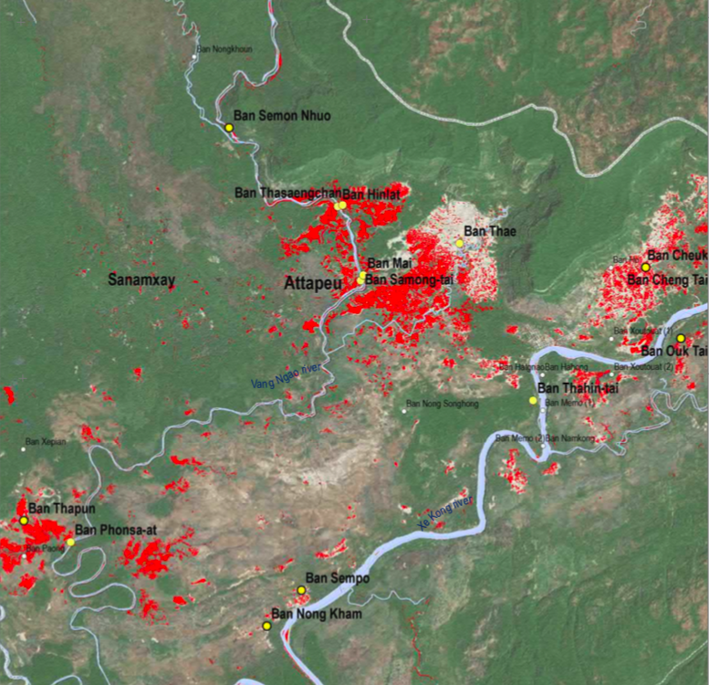
On 23 July 2018, Saddle Dam D collapsed in Lao PDR, causing flash floods in nearby areas. The next day the World Food Programme (WFP) requested UNOSAT to provide satellite imagery analysis and support the humanitarian response. On the same date, UNOSAT triggered the collection of radar imagery over the area of interest and started to analyse the situation. UNOSAT continuously provided details on the increase in inundated areas and the potential impact on villages.
Organisation overview
UNOSAT is a centre of excellence for satellite imagery and geospatial analysis within the UN system. We focus on the provision of satellite imagery analysis and adaptive geospatial solutions to both UN sister agencies, and those non-governmental and international organisation active in mainstream international endeavours such as humanitarian assistance, human rights, and development in general. As a part of UNITAR, we undertake training and research activities.
