SENCE (Environment Systems)
http://www.envsys.co.uk
Overview
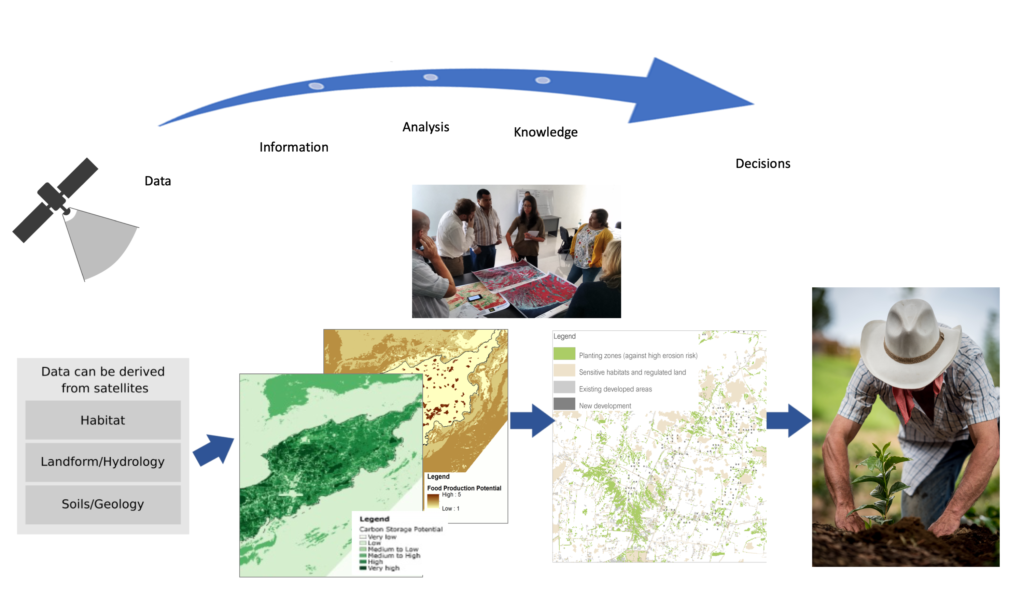
Natural capital is those elements of the natural environment which provide valuable goods and services to people. SENCE provides maps of natural capital stocks to show how well areas of land are able to support ecosystem services such as: food provision, flood protection, pollination, carbon storage, diversity of plants and animals. Decision- makers can monitor natural capital, visualise and estimate the impact of scenarios of change, plan and deliver land management action for long-term sustainable development.
Solution benefits
- Natural capital is those elements of the natural environment which provide valuable goods
and services to people. SENCE provides maps of natural capital stocks to show how well
areas of land are able to support ecosystem services such as: food provision, flood protection, pollination, carbon storage, diversity of plants and animals. - Assess risks to ecosystem services such as from soil erosion, flood risk, storm surge, climate change; model and map how and where these risks can affect people.
- Identify the best places in the landscape to invest to improve natural assets, for example where to plant natural vegetation to reduce erosion, slow water flow to reduce flooding, reduce the effects of storm surges or store carbon.
- Address business or policy needs with new information to produce strategies and plans to deliver resilient land management action, adaptation and long-term sustainable development.
- Demonstrate the value of natural capital to society and identify where investment in natural assets, enhances these for the benefit of people, wildlife and the economy.
- Working closely with stakeholders to demonstrate the benefits of natural capital to deliver community benefits such as cleaner water, more reliable water supply, ecotourism and resilience into the future.
- Scenario modelling shows how natural assets change in response to differing policy futures or land management strategies.
Key technical features
- Satellite optical and radar data is used to map land use, landform, habitat and vegetation structure, delivering vital new environmental information in places that are remote, dangerous and expensive to survey by fieldwork.
- Works from the field or habitat scale up to catchments, regions and countries.
- Supports natural capital valuation, where techniques are used to frame sustainability issues in terms of our main global indicator of value, which is money.
- Uses freely available Sentinel-1 and 2 satellite imagery (10 metre) or other commercially available higher resolution imagery, providing a range of spatial resolution, typically from 5 to 10 metre.
- Works in conjunction with field survey and existing datasets.
- Modelling handles differing scales and types of input data and can incorporate existing non- satellite environmental, cultural and land-use data.
- The method allows for participatory approaches, such as workshops, to engage stakeholders so that their needs, knowledge and values can then be represented.
- Outputs as GIS map layers including KML, data services, reports.
- Underpinned by the SENCE Ecosystem Reference Database which provides the scientific evidence to support the mapping and modelling based upon studies from over 500 peer reviewed journals.
Case studies
Vulnerability mapping in the UK Overseas Territories with Joint Nature Conservation Committee (JNCC) in Anguilla NEA. The SENCE model assessed vulnerability to human life from storm surge and flooding for five UK Overseas Territories. Mapping terrain, coastal water depth and terrestrial vegetation from optical and radar imagery produced a storm surge risk model. Coral reef and mangroves demonstrated an important role in counteracting wave energy and reducing storm impact, informing policy and governance, providing practical solutions, such as siting evacuation areas and informing restoration priorities.
Organisation overview
Environment Systems is an established environmental and agricultural data company, providing trusted evidence and insight to governments and industry across the world since 2003. The consultancy delivers bespoke advice and solutions for land management, monitoring and policy for ecosystems, natural capital evaluation, agricultural trials and agricultural supply chains. The company’s satellite data services (https://data.envsys.co.uk/) deliver always-on, accessible open data insights from satellite earth observations analytics.