Rapid Flood Mapping Service (RFMS) (Telespazio VEGA UK)
http://telespazio-vega.com/
Overview
Rapid Flood Mapping Service (RFMS) provides a quick response in mapping flooded areas in the immediate lead up – and during – a severe weather event e.g. torrential rainfall. Targeted at national disaster resilience agencies and the first responder community. RFMS utilises high-resolution radar data that is unaffected by clouds and is capable of delivery of actual observed flood extent data every 12 hours. Provides maps of the true distribution of visible flood water, enabling quick and efficient response, recovery and relief.
Solution benefits
- Near-real time mapping of flood extents with the possibility of updates every 12 hours. Depending on ground station availability, flood extent layers can be produced within four to five hours of image acquisition by the satellite.
- Reacts to compatible automatic alerts from national weather agencies or an instruction from a customer.
- Works in most weather conditions including cloud.
- Can be enabled over rural and urban areas.
- Use of the COSMO-SkyMed constellation of four satellites means that flood maps derived from the satellite images can be available the day after an alert of an impending flood is received.
- Accurately maps the true distribution of visible flood water, enabling a quick and efficient response, recovery and relief.
Key technical features
- Satellite-derived spatial dataset that highlights the true distribution of visible flood water in both vector and raster formats.
- Uses radar which works at night and can penetrate clouds.
- Uses tasked high-resolution commercial COSMO-SkyMed radar data, in either Spotlight (1 metre) or StripMap (3 metre) modes to match customers’ needs.
- Sentinel-1 data can also be used for flood mapping when available (Sentinel satellites cannot be tasked specifically by the user).
- Can be used as a standalone product with datasets being delivered through a web platform. Alternative methods to match customers delivery needs can also be used e.g. File Transfer Protocol (FTP) and Geoserver.
- High to medium precision mapping can be produced using various Digital Terrain Models (DTM) to match customers’ needs and budget.
Case studies
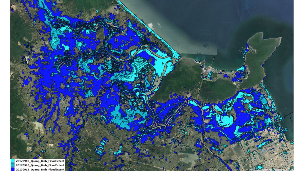
Telespazio developed the capability via the UK Space Agency’s Space for Smarter Government programme and adapted it to provide data and value-add services for IPP projects. In Vietnam, flood waters were monitored in Quang Binh (see figure), and the system is ready to respond to further flood events during the 2019 wet season. The aim is to react to typhoon alerts in Vietnam and map the flood events that follow.
Organisation overview
Telespazio VEGA UK Ltd (TVUK) is a highly experienced consulting, technology and engineering services business, which supports satellite operators and manufacturers worldwide and helps other organisations benefit from space data and services. Based in the UK, it is a wholly owned subsidiary of Telespazio SpA, and employs approximately 140 highly qualified staff with a wide experience in Science, Earth Observation, Geo- Information, Navigation and Telecoms Projects.