
Earth Observation for Flood and Drought Resilience (Airbus Defence and Space) (IPP funded)
www.intelligence-airbusds.com/agriculture
Overview
Earth Observation for Flood and Drought Resilience focuses on alleviating poverty for farmers that currently have little or no access to insurance by demonstrating the efficacy of Earth observation (EO) data for supporting the micro-insurance market. It also focuses on building social and economic resilience to drought and flood by providing economic impact decision-support information, at a national level, about where best to make infrastructure investments or land use changes.
Solution benefits
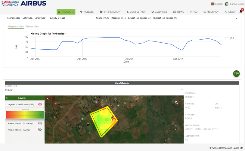
- The information provided will support decision making and the development of improved insurance products that pay out to people in greatest need at the required time, using indices that more accurately reflect the incidence of flood and drought than current measures.
- Reasonable payouts in due time will prevent farmers from selling animal stock to subsidise their incomes when crops fail due to drought or flood.
- These improved insurance products, once demonstrated, shall increase the overall take-up of insurance, allowing micro- insurance companies to spread risks and reduce costs.
- The product is an independent, verifiable information source, thus free from corruption or bribery, which are significant factors restricting the development of this sector among both insurers and customers.
- The solution provides granular information on the likelihood of flood or drought and supports the assessment of the socio-economic impacts of these events, thus assisting policy makers targeting resilient economic development.
- The information enriches the understanding of vulnerability, by using new information to explain how floods and droughts impact upon people.
- This enhances the value of existing information, both meteorological and socio-economic, providing independent verification of flood and drought events and situational awareness of impacts on the ground.
Key technical features
- The solution uses multiple low to medium resolution optical satellite EO data sources including Airbus commercial DMC data, combined with free Landsat, MODIS and Sentinel data.
- The product delivery frequency is every 10 days, with a product resolution of 20 metres.
- The solution provides the ability to view index-based drought impact products relevant to different insurance companies or end users (farmers). This includes analysis of drought characteristics, the nature and extent of historical events and projected future scenarios of climate and land cover change.
- The Future Flood Explorer (FFE) model enables results to be interpolated for different policy responses and climate scenarios.
- The products can be used in a Computational General Equilibrium (CGE) model to help understand the economic impacts of decreases in crop production.
Case studies
This solution will be deployed during 2021, in Kenya, for the micro-insurance market; and in Ethiopia, by providing economic impact decision-support information at a national level.
Organisation overview
Airbus Defence and Space – Intelligence UK, provides satellite image acquisition and timely processing, interpretation, analysis and management, as well as hosting of geospatial data and consultancy services, for many sectors including: central and local government, land administration, agriculture, forestry and the environment. Products and services delivered from our four UK offices provide solutions for our customer base around the globe.
Consortium members include: Vivid Economics, Sayers and Partners Ltd, Oxford University – School of Geography and the Environment and Machine Learning Group.
