Earth and Sea Observation System (EASOS) (Satellite Applications Catapult) (IPP funded)
Overview
EASOS is a platform designed to provide high value decision support to tackle country specific environmental, security, and human challenges. Through its intelligent way of fusing data from terrestrial and satellite sources, EASOS provides knowledge on a wide variety of topics to different government departments on a local, regional, and international scale. Currently the system has three live services: EASOS Flood Watch, Forest Watch, and Marine Watch.
www.easos.org.uk
Solution benefits
- Rapid and cost-effective creation of applications to meet key environmental, societal, and disaster management challenges.
- Flexible allowing automatic connection and ingestion of multiple forms of data including satellite imagery, mapping layers, live telemetry from the field, environmental and weather forecast data.
- Scalable from local to regional and national scale and capable of deploying globally.
- Integrates the very best of British innovation from multiple UK commercial and academic organisations.
- Development paths underway looking at solutions for agriculture, mining, air quality and other applications.
EASOS Flood Watch
- Provide warning of flooding up to 7 days in advance
- Enable preventative action to be taken prior to a disaster event
- Enable the Disaster Management committee to coordinate all agencies, and take preventative measures acting on consistent, reliable information
- Achieve over 90% accuracy for flood alerts with a 12-hour lead time
EASOS Marine Watch
- Reduction in financial impact of marine pollution
- Early warning of impact to environmentally sensitive coastline
- Decision support for containment and cleaning efforts
- Reduce loss of habitat and damage to marine life by deterring ships from pumping bilges off the coastline
EASOS Forest Watch
- Regional level detection and monitoring of logging activities
- Enables enforcement of forestry legislation and management practices
- Help protect the endangered species threatened by their diminishing habitat
Key technical features
EASOS Flood Watch
- Provide warning of flooding up to 7 days in advance
- Forecasts the impact of rainfall
- Continuously monitors river and rain gauge state
- Locate and visualise forecasted flood impact on key infrastructure such as roads, evacuation centres, medical facilities
- Assess human and financial impact of forecasted flooding
- Flood planning for 1 in 5 to 1 in 10,000 year scenarios
EASOS Marine Watch
- Detect potential oil pollution incidents on the surface of the ocean
- Forecast pollution dispersal for the next 84 hours
- Automatic alerts based on areas of interest, oil detection size and forecasted coastal impact
- AIS data integration to help identify vessels which could be responsible
- Model what-if scenarios for oil spills and model the impact of boom deployment
- Rapidly identify nearby vessels which can assist with oil slick assessment
EASOS Forest Watch
- Identify change to the forest canopy in protected areas
- Automatic alerts based on areas of interest, detection size and trends
- Hotspot monitoring using high resolution Radar data
Case studies
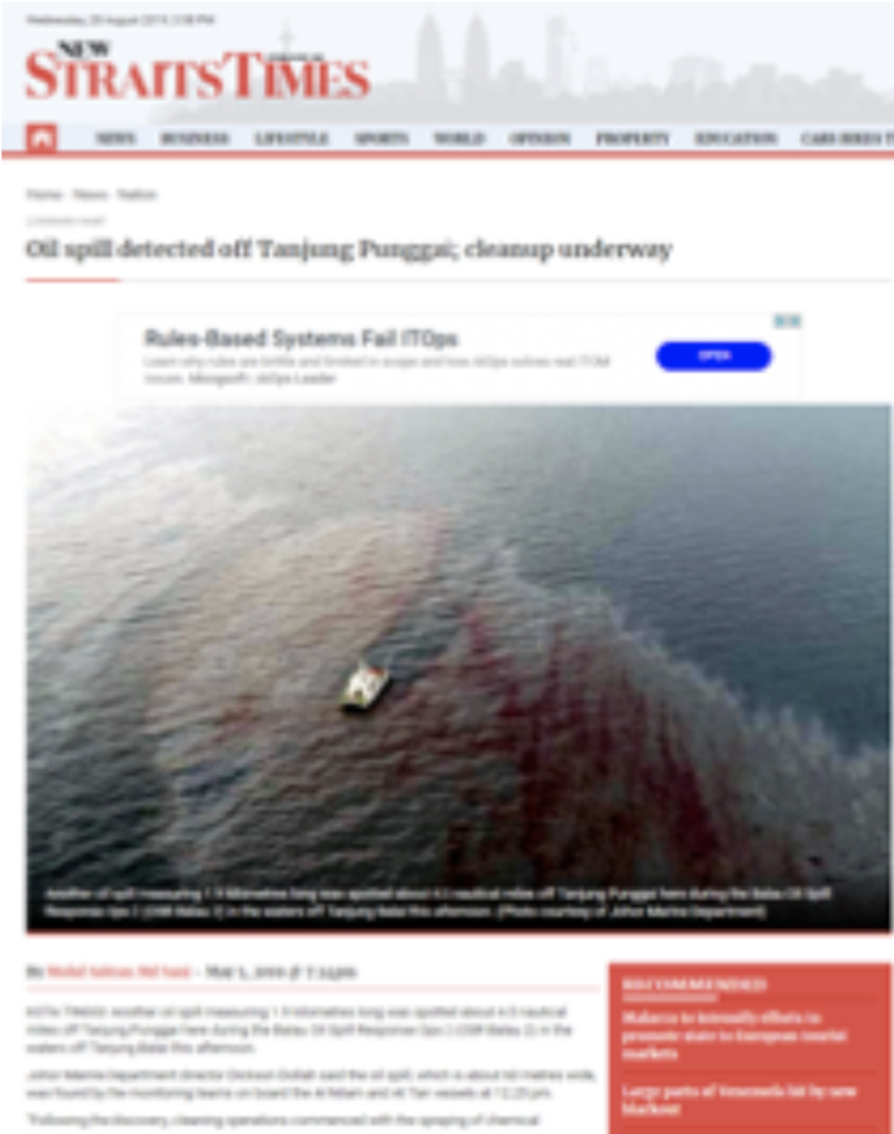
The EASOS solution is currently deployed in Malaysia with three services – Flood Watch, Marine Watch, and Forest Watch, delivering high-value decision support through a series of applications, the system is almost entirely automated, reducing cost, and mitigating delays.
EASOS automatically provides flood forecasts every 6 hours (4 times a day), has detected over 3,000 hectares of deforestation in two areas of interest and successfully stopped oil hitting the Malaysian coastline on multiple occasions. One example featured extensively in the Malaysian media is shown below
Organisation overview
The Satellite Applications Catapult is an independent innovation and technology company, created by Innovate UK to drive economic growth through the exploitation of space. We work with businesses of all sizes to realise their potential from space infrastructure and its applications. Based in Harwell, Oxfordshire, the Catapult was established in May 2013 as one of a network of centres to accelerate the take-up of emerging technologies and drive economic impact for the UK. We are a not-for-profit research organisation which is registered as a private company limited by guarantee and controlled by its Board.