
Drought and Flood Mitigation System (DFMS) (RHEA) (IPP funded)
www.dfms.co.uk
Overview
The Drought and Flood Mitigation Service (DFMS) provides robust meteorological, hydrological, and other Earth observation (EO) information as observations, forecasts, and data archives. Products for monitoring, near and long-term planning, and historical analysis are provided through an on-line portal to users in the government, commercial agriculture, and development sectors. Focussed on reducing the impact of drought and floods, DFMS enables improved agricultural management and preparing for weather conditions in general.
Solution benefits
- DFMS delivers reliable and actionable weather and crop data where up to now it has been unavailable, inaccessible, or of varying quality.
- As a service, using DFMS only requires an internet-connected device, removing the need for capital investment and expert maintenance & development skills.
- DFMS empowers those who cover last mile agriculture with the information to plan and execute their actions better, e.g. with DFMS managers of outgrowing schemes can direct their smallholders to plant, spray, and harvest under optimum weather conditions.
- Weather and hydrological forecasts on two, seven, and 90-day time scales.
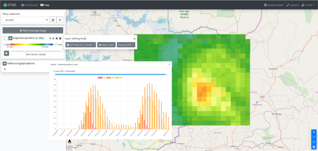
- Space-based monitoring of crop health, water extent and surface temperature and more, at spatial resolutions down to 10 metre.
- Access to monitoring data and forecast archives, going back up to 30 years.
- Includes customisable threshold alarms, for example rainfall levels or drought risks.
- Based on a highly scalable and replicable cloud-based platform.
Key technical features
- No software to install – on-line access via web browser.
- Customisable user interface – users select the maps and charts they want to see.
- Meteorological forecast provided by the UK Met Office using MOGREPS and GloSea.
- Hydrological baseflow, runoff, evapotranspiration, and soil moisture deficit forecasts and associated drought and flood risk indices.
- Normalized difference vegetation index (NDVI) and burned area index (BAI) at 10 metre spatial resolution. Soil moisture and water extent and height at 20 metre resolution and land surface temperature at one km.
- Input data sources include SMOS, MODIS and Sentinel-1 and 2.
- Based on Open Data Cube technology, the open source software to manage satellite data, backed by CEOS, USGS, and the UK’s Satellite Applications Catapult.
- Underlying platform uses any type of EO data (open or commercial; in-situ or remote; optical, radar, LIDAR, etc.) and can host processing algorithms and models.
Case studies
DFMS will be provided as a service to the Ugandan Government. It will enable government officials to provide the Ugandan people with practical information that will help them respond to the effects of climate change. The aim is to use satellite and ground-based data, combined with drought and flood models, to help people respond to effects on agriculture. The initial development of DFMS was supported by IPP.
Organisation overview
RHEA Group is a professional engineering and solutions company, providing bespoke engineering solutions, system development and security services to Space and other critical national infrastructure organisations. RHEA employs over 400 staff, located globally across 11 countries. RHEA operates DFMS from the UK, supported by a consortium of UK organisations, and markets and supports DFMS in Uganda through a local agent.
