CRUST: Climate Resilient Urban Simulation Tool
Overview
Sustainable urban growth requires adequate planning. The current urban footprint and its potential future growth are important factors that affect a city’s ability to become sustainable and improve the quality of life of its citizens. The climate resilient urban simulation tool helps facilitate the analysis of different growth scenarios that allows cities to estimate the future land needs, infrastructure costs, vulnerability profiles and GHG emissions associated with different options.
www.vivideconomics.com
Solution benefits
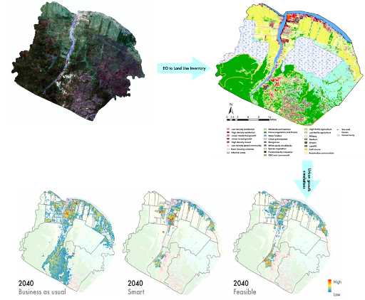
- Combines satellite imagery with volunteered geographic information data to generate automated urban growth and land use inventories which can be further enriched with local data.
- Urban growth simulation tool framework that helps urban planners and policy-makers with visually & spatially-explicit scenarios of future urban growth.
- Simulation framework integrates climate resilience focusing on floods, conservation planning and compact growth to help land use planners to create best use of land plans.
- Allows policymakers to identify future hotspots of development where infrastructure provision is a priority, vulnerable areas which need to be protected from future growth.
- Land allocation tool as part of the framework allows housing departments to identify best consolidated land parcels for low income housing schemes.
- Urban growth monitoring tool as part of the framework helps local governments to monitor the growth of illegal settlements in sensitive areas.
Key technical features
- Automated built environment monitoring using open access multitemporal Landsat and Sentinel imagery which can be combined with high resolution imagery such as Worldview to create detailed land use inventories for a city.
- Uses econometric techniques to estimate future housing demand taking into account future shocks.
- Machine learning based simulation tool which identifies potential drivers of urban growth to spatially allocate future residential, commercial and industrial demand at 30m resolution.
- Can be flexibly adapted for use with any land use classification raster, making it applicable to a wide variety of locations and resolutions.
- Can be coupled with a catastrophic model to integrate present and future hazards and exposure and vulnerability assessments for different scenarios.
Case studies
Georgetown, Guyana: Vivid Economics, supported by Inter-American Development Bank, is working closely with the Ministry of Housing, Central Housing and Planning Authority as well as other parties in Guyana to use the tool to inform flood- resilient land development choices in the capital city of Georgetown.
Addis Ababa, Ethiopia: Vivid Economics, supported by IPP, is using tool to help the National Planning Commission plan for climate-adaptive scenarios for future urban growth.
Organisation overview
Vivid Economics is a leading economics strategy consultancy with global reach. Specialising in cities, climate change, economic development, energy, finance and natural resources, we advise on the most critical and complex policy and commercial questions facing clients, both in government and the private sector, around the world.
Central to our work is robust, evidence-based analysis communicated effectively. We have wide-ranging expertise and skills in commercial strategy, public policy design, economy-wide and market modelling, econometrics and spatial analysis. Our experience is demonstrated in a track record in delivering first-of-a-kind, custom solutions with solid economic foundations.